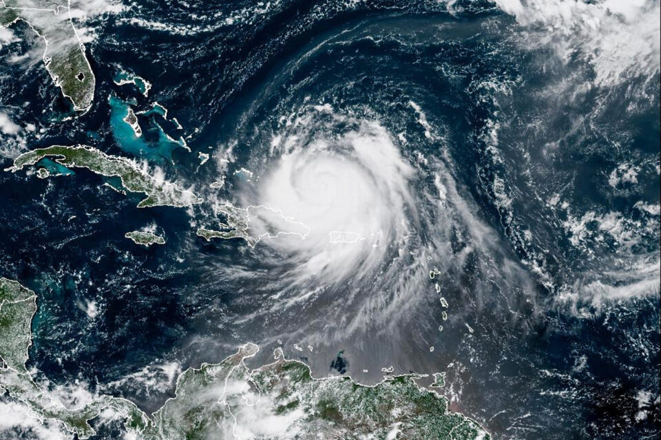

Hurricane Erin flexed back to Category 4 power and its defining 130 to 156 mph winds Sunday night after “completing an eyewall replacement cycle,” the National Hurricane Center said.
The storm 130 miles east-northeast of Grand Turk Island spent the rest of Sunday as a Category 3 cyclone, pushing out winds of 125 mph. It was expected to strengthen by feeding off the warm tropical waters of the Atlantic north of the Caribbean Sea. It had started the weekend at the most powerful hurricane designation, Category 5.
By late Sunday, Erin was back to pushing 130 mph sustained winds and stronger as it moved northwest at 12 mph, according to the hurricane center.
“Some additional strengthening is expected over the next 12 hours followed by gradual weakening,” the center said in a late-night advisory. “However, Erin is forecast to continue increasing in size and will remain a large and dangerous major hurricane through the middle of this week.”
More than 50,000 utility customers were without power in Puerto Rico as the hurricane battered the Caribbean, bringing heavy rain, powerful wind and sizable waves to Puerto Rico and the Virgin Islands.
Luma Energy, Puerto Rico’s private power grid operator, said Sunday night that most of its customers on the island had working electricity following “multiple interruptions.”
“As of 7:30 p.m., 95.1% of customers have electrical service,” it said on X. “The majority of affected customers are concentrated in the regions of Caguas, Mayagüez, and San Juan, as the rain bands have been moving out of Puerto Rico.”
The National Weather Service on Sunday night issued a high surf advisory through Monday morning for Puerto Rico beaches, including Playa Piñones, Parcelas Suarez, Villas del Mar and Villa Christiana in the town of Loiza; Fortuna in Luquillo; Pueblo and Tamarindo in Aguadilla; Bario Obrero, Pueblo and Jareaito in Arecibo; Las Boca in Barceloneta; Machuca in Manati; Puerto Nuevo in Vega Baja; Ocean Park in San Juan; and Barrio Espinal in Aguada.
The advisory warns that waves measuring 7 to 13 feet could strike those beaches through Monday morning. A small craft advisory was also issued through Monday afternoon for seas off the island and off the U.S. Virgin Islands’ St. Croix. It warns operators of small boats that hazardous winds and waves loom offshore.
Sunday night, a National Oceanic and Atmospheric Administration buoy 335 nautical miles east of the Bahamas’ San Salvador Island measured wave heights of 28.2 feet.
Two divers who were swept away by dangerous surf near St. Croix in the U.S. Virgin Islands had to be rescued by local crews Sunday, according to the U.S. Coast Guard. Video of the rescue by St. Croix Rescue Chief Jason Henry showed the divers being pulled onto a boat.
The storm is also expected to bring life-threatening surf and rip currents to the East Coast during the week, the hurricane center said.
It warned residents and visitors of North Carolina’s Outer Banks to monitor the storm midweek.
Officials in coastal Dare County declared a state of emergency effective Sunday evening and ordered the evacuation of Hatteras Island starting Monday morning.
Dare County Emergency Management said in a statement that coastal flooding was possible with Tuesday evening’s high tide. It said high surf is likely to trigger a full closure of beaches along the county coast except for surfers using traditional boards.
“Extreme beach and coastal damage is likely along the oceanside, resulting in a significant threat to life and property,” the agency said.
On the island of Sint Maarten, video showed palm trees swaying in strong winds Saturday. Cleanup crews have been clearing debris around the country since Sunday morning, its government said on Facebook, adding that Sargassum seaweed has washed up ashore as a result of Erin’s impacts. A large amount of the seaweed reaching the shore is referred to as a “Sargassum inundation event,” which can result in harmful toxins that affect people and marine life, according to the National Ocean Service.
Outer bands continue to sweep over Puerto Rico and the Virgin Islands, bringing heavy rain and gusty wind. Rainfall totals of 2 to 4 inches, with up to 6 inches likely in some areas, will be possible and could lead to flash flooding or mudslides.
At a news briefing Sunday morning, Puerto Rico Gov. Jenniffer González-Colón advised residents to stay home if possible.
Video circulating on X showed heavy rain falling in Cidra in central Puerto Rico on Sunday. Other videos posted to social media showed trees swaying in the wind and storm waves on the island.
González-Colón said that there were no residents in shelters and no reports of flooding so far but that flash flooding remains a concern.
The hurricane is forecast to strengthen in the next two days before taking a northerly turn on Monday and Tuesday. Its core is expected to pass by the east of Turks and Caicos and the southeastern Bahamas on Sunday night and Monday, according to the National Hurricane Center. The storm is then forecast to gradually weaken through the middle and latter half of the workweek as it passes between the U.S. and Bermuda.
They are the latest fluctuations in an already volatile storm. Erin rapidly exploded from a Category 2 storm on Friday to a massive Category 5 overnight before weakening gradually to a Category 3 by Sunday morning.
“Some fluctuation in intensity are likely over the next couple of days, but Erin is expected to remain a dangerous major hurricane through the middle of this week,” the hurricane center said in an update Sunday.
Tropical storm warnings have been issued in Turks and Caicos and the southeast Bahamas, according to the hurricane center.
In Puerto Rico’s Sierra Bayamón neighborhood, a suspension insulator broke and a conductor fell to the ground because of inclement weather, Luma Energy said on Facebook. Crews on the ground were working to repair the line Sunday morning.
Luma Energy advised the public to avoid walking or driving through flooded areas, especially near downed power lines.